

Copyright © MMXVII SCOPAC Sediment Transport Study. All Rights Reserved


About the Study
SCOPAC Committee
Chairperson Councillor Mrs M Penfold MBE, West Dorset District Council.
Vice-
Technical assistance provided to Councillors by Mr Lyall Cairns (Southern Coastal Group Chair) and Dr Samantha Cope (SCOPAC Research Chair).
The STS 2012 update
The 2012 update of the SCOPAC Sediment Transport Study (STS) was funded by the Environment Agency under FDGiA, grant number LDW 41230, with additional contributions from SCOPAC.
It is referenced as: New Forest District Council (2017). 2012 Update of Carter, D., Bray, M., & Hooke, J., 2004 SCOPAC Sediment Transport Study, www.scopac.org.uk/sts.
Sediment Transport Study 2012
1. Introduction
The sequence of three almost landlocked harbours of Portsmouth (Photo 1), Langstone and Chichester are shallow tidal basins, which were created after sea levels approached present-
Compared to several other sites in the Solent system, the inundation of Langstone Harbour occurred comparatively late in the Holocene period. Deeply incised river channels occupied the main Langstone and Broom, Channels up until approximately 7-
The four main harbour islands are remnants of low interfluve divides, located on a locally slightly more resistant clay substrate. Archaeological evidence for the navigation of the harbour and the construction of quays in early/mid-
The estuary entrances are very narrow (Photo 1 and Photo 5), so that waves generated outside cannot penetrate far into the harbours. Internal sediment transport and sedimentation processes therefore differ markedly from that at the open coast because tidal currents are the major mechanism and wave action is relatively insignificant due to limited fetch. The intensity of transportation motive forces shows well-
Because of the differing range of sediments and transport conditions the harbours require a different analysis compared to the open coast. A budgetary approach is therefore adopted, involving the identification of sediment inputs, stores, transfers or circulations of sediments and outputs. This approach is appropriate because each of the harbours behave as self-
Environmental baseline data which supports the determination of sediment transport, has been compiled by various independent studies (e.g. Collier, et al., 1995; Dunn, 1972; Budd, 1985; Fontana, et al., 2000; Baily, et al., 2000; Bray and Cottle, 2003; Baily and Pearson, 2007; Cope, et al., 2008) using remote sensing and other techniques. A detailed classification of vegetation types in Portsmouth Harbour (Baily, et al., 2000), and quantification of changes in the extent of saltmarsh in all three harbours (Baily and Pearson, 2007; Cope, et al., 2008; Bray, 2010) has been undertaken. In addition, Baily et al. (2000) mapped areas of bare (unvegetated) mud, sand and gravel derived from large scale, high quality false colour infra-
A major new source of coastal data is from the Defra-
The Southeast Regional Coastal Monitoring Programme commenced in 2002. The Lead Authority is New Forest District Council, with data collection, analysis and reporting led by specialist teams at the Channel Coastal Observatory (CCO), Canterbury City Council and Adur and Worthing Councils. (See CCO Annual Survey Reports for further details).
The Southeast Regional Coastal Monitoring Programme measures nearshore waves using a network of Datawell Directional Waverider buoys. The nearest buoy to the harbours is the buoy deployed off Hayling Island in 10mCD water depth. Between 2003 and 2012 the prevailing wave direction was south-
2. Sediment Inputs
2.1 Marine Sources
» F7 · F8 · F9
Sediment is transported into the harbours from the Eastern Solent. The narrow harbour entrances restrict the entry of waves, but increases tidal current, which are the most important transport mechanisms. Littoral transport is convergent at the mouths of all three harbours, with Portsmouth Harbour entrance functioning as the western cell boundary (Bray, et al., 1995). The tidal regime in each habour is complex, characterised by a double high water (young flood stand preceding slack high water stage) (Halcrow, 2010a and b). Analyses of tidal flow at the harbour entrances by Hydraulics Research Ltd (1959), Portsmouth Polytechnic (1976), Harlow (1980), Wallace (1988) and Halcrow (2002; 2010 a,b,c) indicate that the mean ebb current is of shorter duration but significantly greater velocity than the flood current. There is an elevation difference of 4.1m between Mean High Water Springs and Mean Low Water Neaps at the entrance to Portsmouth Harbour, 4.2m and 4.3m at the mouths of Langstone and Chichester Harbours respectively. At the entrance of Chichester Harbour, maximum spring tide flood velocities are 1.4m per second, and maximum ebb velocities are 3.3m per second. The corresponding velocities for the other harbours are lower, at 0.9 and 1.8m per second for Langstone and 0.95 and 2.04m per second for Portsmouth Harbours. In the shallow water of the upper harbour creeks, tidal velocities do not exceed 0.4m per second. Thus, net bedload transport of coarse sands and gravels is dominantly seaward at each harbour entrance, forming extensive part-
The flood tidal stream is of lower velocity but longer duration than the ebb tidal stream (a mean of 0.7m per second for the Langstone entrance channel and 0.95m per second for Chichester Harbour mouth), thus net transport of suspended sediments (fine sands, silts, clays and organic particles) is into the harbours (Harlow, 1980; Wallace, 1988; HR Wallingford, 1997; Halcrow, 2010a and b). This, however, has not been substantiated, and there is some contrary evidence (HR Wallingford, 1994). These sediments can reach the innermost parts of each estuary, whereupon deposition is assisted by a tidal stand at high water and trapping by intertidal flora. All three harbours may be regarded as virtual sediment sinks (HR Wallingford, 1997), where the rate of sedimentation has kept pace with post mid-
F7 Suspended Sediment Input at Chichester Harbour Entrance (see introduction to Marine Sources)
Harlow (1980) suggested that the fine grained sediments of Chichester Harbour comprise material eroded from the open coast between Hayling and Selsey and placed in suspension by wave action. The harbour perimeter has not significantly changed shape in recent centuries, a feature taken to indicate that sedimentation has kept pace with sea-
Analysis of available data and literature provided no evidence for gravel input by weed rafting and the speculative 2004 arrows have therefore, been removed.
F8 Suspended Sediment Input at Langstone Harbour Entrance (see introduction to Marine Sources)
The contrast between the velocities of ebb and flood tidal streams at Langstone entrance is such that net transport of suspended sediment is into the harbour, Harlow (1980); Wallace (1988); Humby and Dunn (1975). The flood duration is 7.1 hours, that of the ebb 5.7 hours (Gao, 1993). This information has been supplemented by results from a radioactive tracer survey conducted on behalf of Portsmouth Polytechnic (1976). This study monitored the dispersion of sewage effluent (suspended solids) from the Fort Cumberland (outside Langstone Harbour) and Budds Farm (inside the harbour) outfalls during both spring and neap tides. It clearly demonstrates that up to 60% of the effluent released at Fort Cumberland can be transported into the harbour by the first flood tide. Some of the tracer was transported eastward during a spring tide and entered Chichester Harbour, whilst effluent released at Budds Farm tended to be retained within the estuary. It is therefore suggested that suspended sediments are readily transported into Langstone Harbour by the flood tidal streams, and once inside tend to accumulate there. Minerals associated with offshore deposits have been identified in suspended sediments sampled from Langstone, and also Portsmouth, Harbours (Portsmouth Polytechnic, 1976; Algan, 1994). This combination of direct and indirect evidence provides strong qualitative information of net suspended sediment input. However, the process has yet to be quantified to establish its significance. Gao (1993) calculates a potential transport capacity of 22x109kg per year at the Langstone entrance channel, but this figure refers to the total flux associated with both ebb and flood currents.
F9 Suspended Sediment Input at Portsmouth Harbour Entrance (see introduction to Marine Sources)
The relative velocities and durations of the ebb and flood tidal streams (Hydraulics Research Ltd, 1959) differ in a similar manner to those described for Chichester and Langstone entrances. This results in presumed net input, and retention, of suspended sediment (Wallace, 1988), but no quantitative estimate of this effect is available.
2.2 Fluvial Input
The volume of freshwater flowing into the harbours is, as explained below, small in comparison with tidal fluxes, carrying relatively little suspended sediment (Harlow, 1980).
FL1 Hermitage and Brockhampton Streams
Analysis of streams flowing into Langstone Harbour (Portsmouth Polytechnic, 1976) revealed that only the Hermitage Stream supplies freshwater in significant quantity, with a maximum daily discharge of 1.4 million m³. This is less than 0.25% of the spring tidal prism. It was stated in this report that little, if any suspended or bedload material is brought into the harbour by local streams and drainage outfalls, although there are no field measurements to corroborate this. Gao (1993) calculated a maximum daily discharge input of 40.6 x 10⁴m³, and a minimum of 10.3 x 10³m³, but these figures may include some allowance for freshwater ingress via seepage along the northern perimeter of the harbour. Based on various estimates, freshwater discharge is between 16 and 45m³ per second.
FL2 Wallington River
The only significant fluvial input into Portsmouth Harbour is the Wallington River with a flow of between 0.2m³ per second and 33m³ per second (Hydraulics Research Ltd, 1959; Rendel Geotechnics and University of Portsmouth, 1996). It is stated that sediment input from this source is negligible, but was not tested by field measurements.
FL3 River Ems, Chichester Harbour
A suspended load input of 1,450 tonnes per km² per year and bedload of between 268 and 541 tonnes per year is estimated by Rendel Geotechnics and the University of Portsmouth (1996).
FL4 River Lavant, Chichester Harbour
Unpublished Environment Agency data, and estimates using basic formulae (Rendel Geotechnics and University of Portsmouth, 1996), suggest an approximate input of suspended load of 2,100 to 2,400 tonnes per km² per year. Bedload discharge is probably negligible, below 100 tonnes per year.
2.3 Coastal Erosion
» E1 · E2 · E3 · E4 · E5 · E6 · E7 · E8
Sediment can be supplied to the harbours from erosion of both drift and substrate materials discontinuously exposed around their perimeters. Examination of maps indicates that much of the shoreline environment comprises reclaimed land at or below mean high water level, with erosion prevented by protective artificial bunds, earth banks or sea walls. Failure of these structures would arguably result in flooding rather than any significant erosion and sediment supply (HR Wallingford, 1994). Exceptions occur along some sections of the eastern and western shores of Hayling Island (Photo 8), the south eastern shore of Chichester Harbour (Photo 9) and the four major islands in Langstone Harbour, which are not protected and for which there is evidence of erosion of their outlines, and overall retreat, since the late eighteenth century (Allen, 2000a). No parts of the perimeter rise more than three metres above mean high water level so erosion forms low cliffs which can only supply limited sediment volumes even when retreating (Clare, 1996).
Clare (1996) suggests an erosion rate of 0.8m per year for the period 1967-
E1 Warblington Castle (see introduction to coastal erosion)
Harlow (1980) reported that low cliffs of Brickearth were eroding near Warblington Castle. This cliff was 300m in length and yielded small quantities of clayey silt and flinty detritus. Chalky clay and Coombe Rock outcrop on the beach and are also subject to erosion. The cliff exposure is now largely protected by an embankment, upgraded in 1989 and subsequently maintained to prevent breaching.
E2 Tournerbury (see introduction to coastal erosion)
Hydraulics Research Ltd (1987) reported that the earth embankment between Tournerbury and Pound Marsh on Hayling Island was rapidly eroding; it has recently been partially upgraded.
E3 Chichester Harbour (see introduction to coastal erosion)
The perimeter of Chichester Harbour was field walked by Cartwright (1984) to locate archaeological remains exposed in low cliffs, or eroded from them. Although not a geomorphological study, this work identified the areas subject to erosion; the presence of archaeological remains, primarily worked and fire-
Deterioration of sea defences west of Longmere Point, Thorney Island has allowed localised erosion of the earth banks and low cliffs behind, causing development of several scour holes (Calderwood, 1986). These 2-
E4 Creek Point (see introduction to coastal erosion)
Collapse of structures associated with oyster beds at Creek Point has introduced some erosion since 1932 (Hooke and Riley, 1987). This site has recently benefitted from reconstruction. Erosion of low cliffs, 1.5 to 3.0m in height, along the Mengham to Selsmore frontage is also encountered where former saltmarsh has been converted into mudflats (W.S. Atkins, 2000).
E5 Portsmouth Harbour (see introduction to coastal erosion)
A small outcrop of London Clay is subject to erosion at Hardway, Gosport
E6 Langstone Harbour (see introduction to coastal erosion)
The low cliffs south of Stoke, cut into London Clay and Reading Beds on the west coast of Hayling Island are subject to shallow slumping and provide a small sediment yield -
Erosion monitoring conducted by the RSPB, 1988-
E7 Harbour Entrances (see introduction to coastal erosion)
Study of Langstone and Chichester Harbour entrances by Hooke and Riley (1987) revealed significant erosion at Eastney outfall (0.48 m per year 1870-
E8 Saltmarsh erostion - new arrows
E8 arrows have been added to appropriate sites within Portsmouth, Langstone and Chichester harbours to represent input of fine sediment (silt and clay) from historical and ongoing saltmarsh erosion. The following table is taken from the Solent Dynamic Coast Project (Cope et al., 2008) which presents a quantified inventory of saltmarsh loss throughout the harbours, interpreted and mapped from historical (1946-
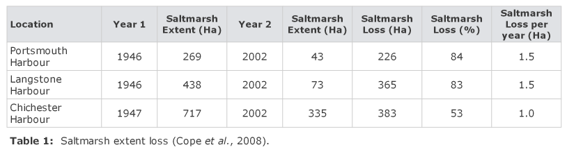
Table 1 presents the earliest (Year 1) to most recent (Year 2) saltmarsh extent mapping for the harbours. The % saltmarsh loss per year can be used to compare the differences in rates of contraction. Details for each harbour are given in section 5.4. Variability in % saltmarsh loss per year is attributed to historical land reclamation, exposure to wave attack, elevation of the marsh, the presence of salt pan formation, sea level rise leading to coastal squeeze, Spartina dieback and dredging (Baily and Pearson, 2007; Cope, et al., 2008).
2.4 Sewage Input
Significant quantities of suspended solids are carried within sewage effluent and this must be considered as an input where outfalls empty into the harbours. Sewage discharges can increase nutrient concentrations which can in turn increase primary production, thereby facilitating sedimentation of organic matter (Portsmouth Polytechnic, 1976). Sewage outfalls exist at Budds Farm (discharging into Langstone Harbour at times of high storm water runoff) and at Fishbourne. Although details of discharges are recorded (Portsmouth Polytechnic, 1976; Thomas, 1987), sewage effluent has been examined as an impact on the biology rather than the sedimentology of the harbours. Despite this, studies with radioactive tracers (Portsmouth Polytechnic, 1976) indicated that once discharged into the harbours, sewage effluent was not easily removed and tended to accumulate. A net water volume input into Langstone Harbour from Chichester Harbour via Chichester Channel (3.5 x 10⁶m³ spring tides; 0.97 x 10⁶m³ neap tides) may have a limited impact on the accumulation of organic material. The net export of 0.73 x 10⁶m³ (springs) and 0.20 x 10⁶m³ (neaps) of water from Langstone to Portsmouth Harbours, via Ports Creek, is considered to be negligible in this respect. Major changes in sewage and flood water discharge into Langstone Harbour became effective from late 2001, thus effectively removing this input source.
3. Sediment Transport within the Harbours
Introduction
Although some beaches within the harbours have a maximum fetch of up to 5km, wave generation is inhibited by shallow water so only limited energy for sediment movement is available. The maximum recorded significant wave height in Portsmouth Harbour is 0.50m, with the 1 in 100 year signifcant wave height estimated to be 0.80m (Halcrow, 2010 a, b, c). Waves of this height would only occur along the northern shorelines in association with southerly winds (HR Wallingford, 1994, Halcrow, 2010 a, b, c). In sheltered areas, such as the Camber, wave heights are less than 0.20m (Halcrow Maritime, 1999; Halcrow, 2010 a and b).
The Coastal Monitoring Programme principally provides lidar and aerial photography data for the harbours, with topographic baseline survey data limited to the western shore of Hayling Island. Analysis indicates negligible changes in beach widths and levels, with unquantifiable low volumes of sediment deriving from erosion of low cliffs and banks. Sediment is transported by several mechanisms:
3.1 Littoral Transport
LT12 Thorney Island
Harlow (1980) suggested that littoral drift in all of the harbours was possible in some of the wider embayments, but does not give any specific locations. An example is the bay between Marker Point and Longmere Point on Thorney Island (Chichester Harbour) where Calderwood (1986) reported apparent north-
LT13 South-East Chichester Harbour
The presence of thin, narrow gravel spits, such as Ella Nore and Horse Pond in south-
LT14 Western Hayling Island
Analysis of Coastal Monitoring Programme data supports northwards shoreline drift at negligible to low rates indicated by the growth directions of small and historically impersistent shoreline gravel spits (Photo 11 and Photo 12) fed by local eroding cliffs and banks.
3.2 Tidal Sediment Transport
» T1
Sediment transport by tidal currents primarily involves a reversing motion of suspended material in response to ebb and flood tidal flow. Information reviewed in previous sections indicates net seaward transport (output) of coarse materials (bedload) and net shoreward transport (input) of mostly fine materials (suspended load). Net transport through the entrance channels is relatively small in quantity. Few studies of the pathways of transport have been conducted but the majority of transport is probably concentrated in tidal channels where current velocities are greatest (Gao and Collins, 1994; HR Wallingford, 1994, 1997). Detailed investigations of current velocities over a range of tidal conditions in Langstone Harbour indicated the likely sediment transport paths (Portsmouth Polytechnic, 1976). This study, and Gao (1993), showed that currents were principally westward at the northern connections between harbours so that a small quantity of net suspended sediment transport might be expected from Chichester to Langstone and from Langstone to Portsmouth Harbours. However, most research indicates that sediment transport is mostly confined to a closed circulation within the harbour system (Portsmouth Polytechnic, 1976). The release of fine sediment formerly stabilised by Spartina saltmarsh has increased sediment concentrations in flood tide streams, leading to net accretion in the upper part of tidal channels in Chichester Harbour (HR Wallingford, 1994a, 1999). A part of this load may derive from the abrasion of the expanding area of mudflats. Small, transitory low elevation banks in the north-
T1 Sand Circulation on Sword Sands by Tidal Streams
A sidescan sonar survey and analysis of air photos covering 30 years revealed the presence of sand waves on Sword Sands (Langstone Harbour) which suggested bedload sand transport close to the harbour entrance (Humby and Dunn, 1975). Measurement of these sand waves indicated intermittent movement associated with the progression of tides from springs to neaps. Transport was northward in the centre of the bank and southward along the edges. Although the scope of study did not reveal the full extent of sediment circulation, it was concluded that dynamic stability of the bank was preserved despite rapid transport rates due to the existence of separate ebb and flow channels and associated transport pathways. It was inferred that bank instability could be caused by variations in sediment supply. Similar circulation systems probably operate in other parts of the harbours, but as yet they have not been detected.
3.3 Gravel Rafting
Attachment of buoyant weeds to gravel sized particles on beaches around the harbour perimeter was observed by Harlow (1980) and Wallace (1988). These were frequently larger than unattached clasts; some were well rounded whilst others were angular. Concrete and brick fragments were also present. It was concluded that more rounded pebbles are or had been transported into the harbours from the open shore whilst sub-
4. Sediment Outputs
4.1 Tidal Current Transport Output
Refer to Halcrow (2010 a, b and c) for a succinct account of the hydrography of Portsmouth and Langstone Harbours.
Sediments are transported out of the harbours by the dominant ebb tidal stream. However, the longer duration of the flood tidal stream causes net input of both coarse and fine suspended sediments. The greater velocity of the ebb tidal stream results in net output of sand and coarser materials which form semi-
4.2 Land Claim
Significant areas of Portsmouth Harbour and, to a lesser extent, Langstone Harbour have been reclaimed (Hydraulics Research Ltd, 1959a and b and 1987; Portsmouth Polytechnic, 1976; Colebourn, 1984; Hooke and Riley, 1987; Privett, 1990; HR Wallingford, 1995; Universities of Portsmouth and Newcastle, 2000; Cope et al., 2008; Halcrow, 2010a). Land claim has impounded large volumes of previously potentially mobile harbour sediment so that this practice must be regarded as an output. Although the above studies record major areas and dates of land claim, few precise details of the volume and character of sediments are known. Land claim also affects harbour sediment budgets as the tidal prism is reduced, tidal currents diminish and sedimentation is stimulated. This effect was theoretically calculated for Portsmouth Harbour by Hydraulics Research Ltd (1959a and b) using a physical model. The potential impact of two proposed major reclamations was investigated at several points in the major tidal channel, and it was concluded that ebb and flood currents could be reduced by up to 25%. The effect of this at the entrance channel was modelled, using coloured sand tracers. Results showed that material would be flushed out of the harbour entrance but that it would tend to be re-
The impact of land claim on the tidal prisms of both Langstone and Chichester Harbours is probably small (W.S. Atkins, 2000b), and its effect on the sediment budget of the harbours is therefore difficult to determine because even slightly diminished tidal flows reduce both sediment inputs and outputs. Circumstantial evidence suggests that it may have greatest effect on reducing marine inputs. Universities of Portsmouth and Newcastle (2000) calculate that just over 9% (circa 85 ha.) of the pre-
4.3 Dredging
Several main channels in Portsmouth, Langstone and Chichester harbours are dredged for navigational purposes and parts of their tidal deltas are also dredged for the same reason, and previously for aggregates. These practices represent permanent actual outputs from the harbour sediment systems, although aggregate removal has been discontinued since the early 1990s.
Portsmouth Harbour
The entrance (Photo 1) and approach channels are routinely maintained for navigational purposes, with less frequent capital dredging. The narrow entrance and consequent strong (ebb) tidal currents produce a "self-
The inner Camber basin is dredged to 1.8m below CD, except for the Wightlink terminal where the vessel berth is maintained to 3.5mCD (Halcrow Maritime, 1999). Significantly greater depths, up to 11.2mCD exist alongside the berths in the Naval Base and the Commercial Docks at Flathouse/Continental Ferry Port.
Licensed (FEPA) maintenance dredging of navigation channels between 1987 and 1997 removed 237,000 tonnes from within Portsmouth Harbour and 333,000 tonnes from Hamilton Bank and Spit Sand immediately south of the harbour entrance. The latter figure may, however, underestimate the actual total. (Universities of Portsmouth and Newcastle, 2000). Capital dredging for the same period was confined to the harbour, and accounted for 1,530,000 tonnes. Whilst maintenance dredging removed essentially mobile sediment, capital dredging involved increasing water depths at berths, quays, docks and marina basins in addition to the depth of approach channels. It therefore also removed previously immobile sediments. The figure for maintenance dredging gives a very crude approximation of sediment input and internal reworking for this ten year period. All dredged material ("spoil") was deposited at the Nab dumping site at the entrance to the East Solent, and therefore represented a significant output term in the harbour's sediment budget. It is possible that between 2 to 5% of the above totals are actually retained, in the form of banks marginal to the main channels created by the dredging process.
As navigation channels have been progressively deepened, both ebb and flood tidal current velocities have increased by small amounts. This may have either inhibited sedimentation or promoted accretion in upper harbour areas. Neither of these effects can be demonstrated from existing hydrographic data (Universities of Newcastle and Portsmouth, 2000). The effect of dredging on the overall harbour sediment budget is therefore impossible to evaluate.
Langstone Harbour
The harbour entrance channel, Langstone Channel (up to Bedhampton), Kendall’s Wharf and Broom Channel are currently dredged for navigational purposes (Universities of Portsmouth and Newcastle, 2000; Halcrow, 2010a). Langstone was a port until 1914 and approach channels within the harbour were dredged over the period 1882-
There are several references to dredging activity within the harbour which are not readily substantiated by quantitative data. Portsmouth Polytechnic (1976) state that Kendall Brothers, operating out of Kendall's Wharf, own the 'prescriptive right' to dredge Sinah Sands. This was continued (up until 1995) at the rate of 'several thousand tonnes' per annum. This sediment was destined for use on land, hence represented a loss to the system. Whilst the right to dredge still exists, future major dredging activity in this area is not foreseen. Two other areas subject to dredging are (i) the approach channel to Bedhampton Quay in the north of the harbour, which was dredged between 1970 and 1975 (Portsmouth Polytechnic, 1976) and 1991-
Quantitative information relating to dredging activity in Langstone Harbour reported by the Universities of Portsmouth and Newcastle (2000), based on FEPA licence data indicate that a total of 143,190 tonnes of sediment was dredged from Langstone Harbour and its approaches between 1987 and 1997. However, it is uncertain as to precisely how much material removed from the East Winner was utilised subsequently in local beach recharge operations, which therefore would not amount to a net loss from the regional sediment budget. It can be stated with certainty that the material periodically dredged from Bedhampton channel and dumped at the offshore Nab Tower site represents a loss from the system. This channel is currently maintained at a depth of 1.8m below Chart Datum, to give access to aggregate unloading at Bedhampton Quay. However, this dredging must be assessed in light of the fact that it is not continuous and hence any impact may be of limited temporal extent.
Chichester Harbour
Routine maintenance dredging is undertaken for navigational purposes on the ebb tidal delta outside the harbour, with part of the spoil used to maintain the replenished beach in south-
5. Sediment Stores
Mineralogic analysis of estuarine clay-
5.1 Beaches
Gravel and sand beaches exist around parts of each of the harbour perimeters, but description is incomplete and fragmentary. Harlow (1980) described a beach near Warblington Castle composed of granules and pebbles up to 75mm diameter. A significant quantity of the beach clasts is larger than the modal size of those in adjacent cliffs indicating transport, and sorting, from another source. Hydraulics Research Ltd (1987) mention appreciable gravel accumulations seawards of Portchester Castle, and Calderwood (1986) reported an upper gravel beach on Thorney Island between Marker Point and Longmere Point. Thomas (1987) also identified an "upper shore gravel" around the perimeter of several parts of Chichester Harbour. Sampling revealed that 15% of the material was less than 63 mm diameter and 25% to 60% was greater than 4 mm diameter.
Gravel beaches of significant width and height occur along much of the west facing shores of Thorney and Bosham peninsulas, and the west and south-
Gravel beaches and spits also occur around Pilsey Island (Photo 15) and along the south east margin of Chichester Harbour (Photo 6).
No study has examined the sedimentology of the harbour beaches in sufficient detail to determine the origins and stability of this material. Some may have been artificially introduced during previous centuries, but most probably derives from a combination of the erosion of Quaternary gravels and sands in harbourside bluffs, the reworking of harbour bed sediments and occasional input from external marine sources during very high energy conditions.
5.2 Sand Banks
It was reported by Harlow (1980) that the coarsest sediments in the harbours were located close to the entrances and that they became increasingly finer further up-
Portsmouth Harbour
The sedimentology of Portsmouth Harbour is very poorly covered by the literature except in two ecological studies of Stamshaw and Tipner Lakes (Thomas et al., 1989a and b). These studies include maps of surface sediment distribution, showing extensive muds and an area of fine sand within Stamshaw Lake. Sampling revealed a median grain diameter of 0.16 mm with 16% <63µ m and 84% between 63µ m and 4mm.
Langstone Harbour
Three distinct sand banks have been identified at the junctions of the major channels and their positions are indicated by Dunn (1972), Portsmouth Polytechnic (1976), and Hydraulics Research Ltd (1987). Mallard Sands are the furthest from the entrance and comprise the finest sediments, being composed of sandy mud (Dunn, 1972 and Hydraulics Research Ltd, 1987). Sinah Sands are almost adjacent to the entrance but east of the main ebb and flood tidal channels, which may be mutually evasive. They are composed of fine sand (Dunn, 1972) with a mean diameter of 0.17-
Chichester Harbour
Thomas (1987) identified sand flats as a distinctive habitat covering 164 hectares (8% of total intertidal area), mostly near the harbour entrance. This area was characterised by material within the 1 mm -
5.3 Mudflats
The mudflats are generally situated away from the entrances, in locations where tidal current velocities are weak and fine sediments can settle during tidal stands (Harlow, 1980). Mudflats are now of much greater extent than 20-
Portsmouth Harbour
Very little information is available regarding the sedimentology of Portsmouth Harbour. Colebourn (1984) stated that in some areas the harbour mud was overlain by a thin veneer of gravel, but evidence supporting this view was not presented. Detailed surveys of limited areas have revealed substantial areas of mud in Stamshaw and Tipner Lakes (Thomas et al., 1989 a and b). Sampling in Stamshaw Lake enabled identification of an upper shore fine mud (mean diameter size 0.02mm with 94% <63µ) and a lower shore mud (mean size 0.05 with 54% <63µ). The morphology of the main mudflats was studied by Hydraulics Research Ltd (1959) using 5 charts between 1783 and 1954 and a field survey in 1956. The low water and 3 fathom contours were compared and no significant changes were detected. This stability was at that time attributed to stabilisation of salt-
Langstone Harbour
The mudflats are composed of a mixture of clay, silt, very fine sand and organic matter (Portsmouth Polytechnic, 1976; HR Wallingford, 1997) and represent a long-
Chichester Harbour
Thomas (1987) calculated that mudflats covered 1298 hectares, 61% of the total intertidal area. These areas were characterised by a high proportion of silt and clay with veneers and possible marginal chernier accumulations of coarse clastic material.
5.4 Spartina and Saltmarsh
Substantial parts of the harbours became colonised by Spartina anglica beginning in the first decade of the twentieth century. The swards of grass interrupted water flow and increased sedimentation so that large areas of high level Spartina marsh accreted up to 1.5m above the level of the adjacent mudflats (Hall, 1979; Bray, 2010), ultimately occupying about 20% of the total (combined) harbour areas. Since the early 1950s dieback of Spartina anglica has occurred, a slow process initially, but accelerating in the mid-
The literature previous to the Solent Dynamic Coast Project (Cope et al., 2008) does not specify the condition of Spartina anglica salt marsh in Portsmouth Harbour other than to mention a general decline, with some areas surviving in the North West (Photo 24) and virtual elimination from central areas, Stamshaw and Tipner Lakes and the Portchester channel. Low 0.5m to 1m eroding bluffs now separate mudflats from residual areas of Spartina, e.g. Fareham Creek and Portchester. The latter occupy some 140ha in several isolated areas in the north-
In Chichester Harbour accelerated dieback of Spartina began around 1967 and has until recently been comparatively more gradual and spatially variable. Exposed sites have generally suffered most from erosion e.g. the south and east facing shores of the Thorney and Chidham peninsulas (Photo 19) the south east shore, particularly the stretch from Itchenor to Rockwood (Hydraulics Research Ltd, 1987). Sheltered sites suffered less e.g. Bosham Channel (Photo 25). Thomas (1987) calculated that Spartina marsh covered 611 hectares (29% of the total intertidal area) in 1984-
Following laboratory experiments, Tsuzaki (2004, 2010) found anaerobic soil conditions with impeded drainage to be the most likely cause of the dwarf growth forms and lack of re-
Several of the research papers cited above note that in all three estuaries there has been only minor changes to the spatial plan of the network of tidal channels (creeks) over the past two hundred years. From this it might be inferred that sediment release from Spartina loss derives principally from the reduction of elevation and recession of the leading edge of inter-
5.5 Thickness of Harbour Sediments
Borehole investigations have yielded site-
5.6 Suspended Sediments
Sampling of suspended sediments was undertaken by the Admiralty at seven sites in Portsmouth Harbour, collected from various depths at hourly intervals on a spring tide. Maximum concentrations of up to 100ppm by weight were recorded in Tipner Lake and Fareham Creek. These compared with a maximum concentration outside the harbour of 10ppm and indicated that suspended sediments accumulate within the harbour (Hydraulics Research Ltd, 1959a), where concentrations in the north-
Microscopic analysis of these suspended sediments revealed them to be mostly clay and silt size, medium sand, including flocculated particles up to the size of coarse silt. They are much larger than comparable sediments previously studied in other regional estuaries, a feature attributed to biological (mucus) binding. These flocs are relatively unstable, aggregating and disaggregating according to the hydraulic forces acting upon them (Humby and Dunn, 1975). Although the clay minerals within flocs matched local geological materials (using X-
Suspended sediment concentration values on spring tide currents suggest that a layer some 20mm thick of silty clay is entrained on a single tidal cycle, with a proportion of this load entering the Itchenor and Bosham channels on the flood tide. Perhaps 75% of suspended load introduced by flood tides is removed seawards by succeeding ebbs. An unknown proportion of fine sediment thus removed from the harbour re-
6. Sediment Budget
Analysis of sediment inputs and outputs based on existing information indicates significant, but largely unquantified input of suspended sediments through the harbour entrances. Natural outputs are limited to some immediate removal or later remobilisation of this input so the harbours have been subject to net accretion over recent millennia. A small quantity of coarse sediment input, by wave-
7. Knowledge Limitations and Monitoring Requirements
Data collected by the Defra-
The Southeast Regional Coastal Monitoring Programme commenced in 2002. The Lead Authority is New Forest District Council, with data collection, analysis and reporting led by specialist teams at the Channel Coastal Observatory (CCO), Canterbury City Council and Adur and Worthing Councils. Longer term Coastal Monitoring Programme data, when combined with other data sets, academic research and historical studies may enable sediment budgets, transport rates and directions to be identified and/or validated in the future, although the lack of significant wave energy and the poor development of beaches means that shorelines in this unit are not suited for definitive studies of drift.
Notwithstanding results from the Southeast Regional Coastal Monitoring Programme recommendations for future research and monitoring that might be required to inform management include:
Input of suspended sediment through the harbour entrances is clearly an important contribution to harbour budgets, but has not been adequately quantified. It could be determined from measurements of suspended sediment concentrations at each harbour entrance, coupled with simulated numerical modelling of the ebb depth-
Erosion of the harbour perimeters is a current process but sediment supply from this source has not been systematically quantified.
The input of organic material by primary production and the fate of this material upon decomposition have not been assessed using budgetary concepts. Similarly the sediment input of sewage effluent has not been evaluated nor has a precise relationship been determined between sewage discharges and increased primary productivity, which stimulates the production (input) of organogenic sediment.
Detailed, systematic surveys of harbour surface (seabed) sediment distribution are required. Existing maps only cover limited parts of Langstone Harbour and sediments previously sampled have not been fully analysed or mapped. Existing information should be used to plan field surveys of areas not previously studied, e.g. much of Portsmouth Harbour, to provide basic surface sediment data. Some limited sampling should be undertaken to characterise the sediments identified and provide quantitative information against which future variations can be measured.
Beaches around the harbour perimeter should be examined to determine their variable extent and sediment composition.
Spartina anglica dieback has been recorded and mapped by Haynes and Coulson (1982); Budd (1985) and Collier and Fontana (1996) for Langstone Harbour. However, the fate of sediments eroded from moribund Spartina marsh has not been established. Photogrammetric analysis of mudflat levels and tidal channel morphology (Collier and Fontana, 1996) indicates that some channels in the northwest and southeast have shallowed since the early 1980s, suggesting that one cause might be sediment redistribution resulting from the release of material from areas of Spartina mortality. Some areas of saltmarsh cliff erosion are balanced by co-
The apparent closed sediment circulation established by Humby and Dunn (1975) for sand banks near the entrance to Langstone Harbour is an important observation, for it showed how transport could be rapid yet net sediment accumulation could remain stable. Assessment of the effects of any interference of the harbours, e.g. land claim and dredging is only possible when such circulations are understood. It is therefore suggested that other sand banks within the harbours should be similarly studied to determine whether closed or balanced circulation systems operate.
The main references for fluvial discharges typically date from the 1990’s and further fieldwork would be needed to assess whether discharges have increased with and if so the potential effect on sediment pulses.
Portsmouth, Langstone and Chichester Harbours
 LITERATURE REVIEW
PHOTOS
MAP
LITERATURE REVIEW
PHOTOS
MAP


|
01 |
|
|
02 |
|
|
03 |
|
|
04 |
|
|
05 |
|
|
06 |
|
|
07 |
|
|
08 |
|
|
09 |
|
|
10 |
|
|
11 |
|
|
12 |
|
|
13 |
|
|
14 |
|
|
15 |
|
|
16 |
|
17 |
|
|
18 |
|
|
19 |
|
|
20 |
|
|
21 |
|
|
22 |
|
|
23 |
|
|
24a |
|
|
24b |
|
|
25 |
|
|
26a |
|
|
26b |
|
|
27a |
|
|
27b |
|